|
 |
A Short History
of the Duwamish River
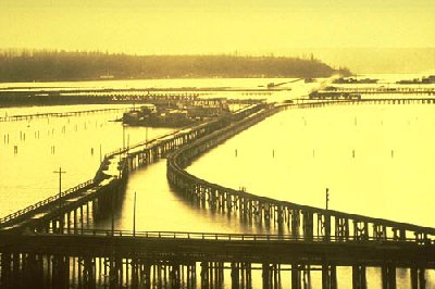
View west across
Spokane St. in the early 1900s. As was the case for many urban waterways
around the world, shipping and industry changed the Duwamish River dramatically.
|
|
Over the last 100 years, the Duwamish
has been straightened, dredged, and concretized, reducing what was 14 miles
of meanders and wetlands to 5 miles navigable by all but the largest ships
and barges. Nearly all of the native habitat - mudflats, marshes, and
swamps surrounded by old growth Cedar, Douglas Fir, and Hemlock trees - were
replaced by concrete factories, shipping terminals, and wrecking yards. The
Duwamish Tribe, the first human inhabitants of the river, were
progressively marginalized in a tragic, yet familiar
series of broken agreements and land grabs by the US government
and some of the area's early white settlers.
The pollution resulting from years of runoff and dumping of toxic wastes
led to the Duwamish's designation as a Superfund site in 2001 - a designation
reserved for some of the most contaminated places in the US. Still,
as a working waterway, the Duwamish tends to be invisible to many of Seattle's
residents.
The Transformation of a Watershed
In the late 1800s, the watershed around the Duwamish River looked quite different
than it does today. Four rivers drained into the Duwamish, which subsequently
drained into Elliott Bay - the Green, the White, the Black, and the Cedar.
After a large flood in 1906, the White River was diverted to drain into the
south end of Puget Sound, near Tacoma. The construction of the Lake Washington
Ship Canal lowered the water level of Lake Washington, causing the Black
River to disappear altogether. The Cedar River was re-routed to drain into
the south end of Lake Washington.
At this point, because the Green was the only river that continued to drain
into the Duwamish, the two were actually one river. However, the portion
that was dredged and straightened - the last 5 miles - continued to be known
as the Duwamish.
This map
from the Seattle Times overlays the Duwamish of 1909 with the river's path
today.
Traces of the Old Duwamish Today
Although the path of the Duwamish was constantly changing as it made its
way to Elliott Bay, vestiges of some of its meanders still remain, commemorating
its shape at the time it was straightened.
In Georgetown,
Oxbow
Park commemorates an early flow channel of the river, and the historic
steam plant that brought power to the neighborhood is now quite a bit inland.
A pumping station for the steam plant, at Gateway Park (the end of
8th Avenue S. on the Georgetown side of the river), was installed after
the river was straightened.
On the South Park side of the river, Kellogg Island at Terminal 107 remains
from before the Duwamish was straightened (see this
Seattle
Times article for location and description of the area). The boat slips
along both sides of the river are all slivers of meanders, echoing the river's
early days.
Some More Links:
"The
Road Back." A great feature on the Duwamish, from 2004 (Pacific
Northwest Magazine)
A history
of South Park, from HistoryLink
Culture
and history of the Duwamish Tribe, from the Duwamsih Tribe website. Extensive
articles and some beautiful photos in the "oral history" section.
The Duwamish River Cleanup Coalition
is the official watchdog of the Superfund cleanup on the Duwamish,
and is the best place for information on the state of
the Duwamish today or how to get involved in cleanup and restoration
efforts.
|
HOME/FAQ
SCHEDULE
MAP / DIRECTIONS
CONSTRUCTION
JOURNAL
PHOTOS
PARTNERS
DONORS
THE ARTISTS
ART & ISLANDS
THE DUWAMISH
VOLUNTEER/DONATE |